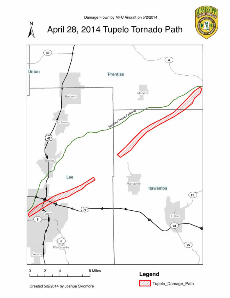
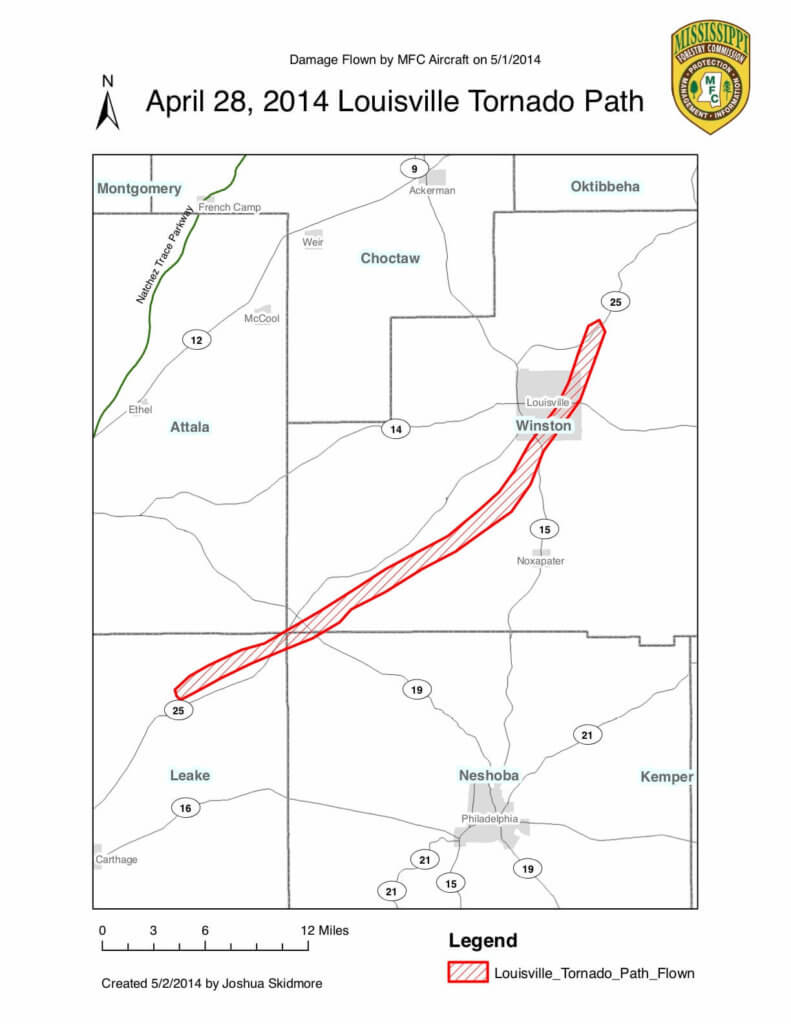
April 2014 Storm Damage Assessment
This is a summary of the aerial detection flight of the tornado outbreaks and following timber damage that occurred on April 28, 2014.
This is a summary of the aerial detection flight of the tornado outbreaks that occurred on 4/28/2014. The damaged areas were flown for timber damage assessment on 5/1-5/2 2014. The flights were conducted by Gus Dear (pilot), Joshua Skidmore and Michael Hughey of the Mississippi Forestry Commission.
The areas affected were approximately 31,854 acres total, of which 22,211 were forested acres (9,017 acres pine, 2,629 acres mixed timber and 10,565 acres hardwood). A 1/8 mile buffer from the main damage was used to calculate additional loss and affected forest areas not necessarily lying on the ground, but damaged by the storm. These areas may or may not fully recover as insects, diseases and other stressors tend to cause further timber loss.
The economic impact on forested acres is estimated at $14,326,895 (using $5-8 per ton for pulpwood and $25-30 per ton for sawtimber). Information by county is listed below:
| Name | Pine Acres Damaged | Hdwd Acres Damaged | Mixed Acres Damaged | Total Acres | Avg Value Per Acre | Total Value |
| Lee | 401 | 775 | 237 | $638 | $902,352 | |
| Itawamba | 232 | 2851 | 139 | $775 | $2,500,132 | |
| Prentiss | 175 | 2234 | 83 | $597 | $1,490,859 | |
| Leake | 2147 | 1093 | 610 | $563 | $2,167,546 | |
| Neshoba | 1131 | 214 | 118 | $513 | $751,065 | |
| Winston | 4931 | 3398 | 1440 | $666 | $6,514,938 | |
| Total Values | 9017 | 10565 | 2629 | 22,211 | $14,326,895 |
The acreage was calculated using a 2003 cover type layer provided through MARIS. The average volumes are gathered from current MS Institute for Forest Inventory (MIFI) data. This estimate takes into account young sub-merchantable stands as well as mature timber. This estimate will be low for individual stands and/or landowners as some experienced total loss in affected areas of high value trees. The tornado damage affected 6 different Mississippi counties.
Estimates for only Private Non-Industrial Landowners (PNIF) are as follows (I removed federal / state and public land acres):
| Name | Pine Acres Damaged | Hdwd Acres Damaged | Mixed Acres Damaged | Total Acres | Total Value |
| Lee | 401 | 775 | 237 | $902,352 | |
| Itawamba | 232 | 720 | 139 | $717,842 | |
| Prentiss | 130 | 20 | 11 | $53,243 | |
| Leake | 1190 | 956 | 591 | $1,481,055 | |
| Neshoba | 1131 | 214 | 118 | $751,065 | |
| Winston | 3877 | 3072 | 1256 | $5,572,207 | |
| Total Values | 6961 | 5757 | 2352 | 15,070 | $9,477,764 |
This information is current as of 5/2/2014. There have been reports of other damaged areas, but aerial reconnaissance has shown spotty, localized damage with no distinct damage paths that can be followed. Further information will be processed regarding damage from these storms as it is reported.
Two maps created by the MFC are attached showing areas of greatest damage. These maps were created using MFC aircraft and the sketch-mapper technology. Please contact Josh Skidmore at the information provided for more information.